EIA report and also compares with a freshly generated GIS data. Following are the excerpts from the discussion section of the research paper as it appears in the article:
- Wrong citation of satellite data resolution: 5m spatial resolution instead of 5.8 m.
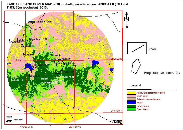
- Acquisition date of satellite data is not mentioned in the EIA report. Date is important because the project area lies amidst tropical dry deciduous forest. From March to May it is a leafless period. Conducting a study regarding forest would not be achieved since it would give an appearance of scrub as all trees (mainly mixed forest) would have shed their leaves. An appropriate season is from November to January wherein the Trees are in good phenological condition.
- The project proponent has failed to produce a false colour composite, which is the basis of land use and land cover classification. Some features can be visually seen and interpreted from it. In fact, interpretation keys for land use /land cover are prepared from false colour composite based on tone, texture shape and colour.
- Ground truth data collection: the project proponent states that information on wastelands; agriculture, mining and industries were collected for verification. This area is dominated by agriculture and tropical dry deciduous forests and Bamboo plantation. No mining areas and no industrial unit exist in this area as of now.
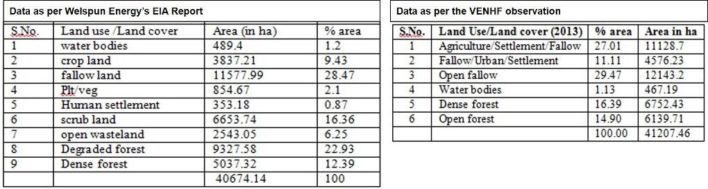
- The project proponent has not mentioned any accuracy results and the verification of classified data. They mention that the land use/land cover classification was followed as according to national standards, but fail to give further clarification. The standard which is required used for Land use/Land cover classification system and is widely followed is the one proposed by Anderson (1971). The minimum level of interpretation accuracy in the identification of land use and land cover categories from remote sensor data should be at least 85 percent.
- The analysis done by project proponent (assumed to be between March-May, 2011; as they submitted the EIA) emphasizes that the study area is dominated by scrub and fallow land and that they are useless to the local residents and farmers. Whereas ecologically scrub and grasslands are very much significant in supporting a large number of medicinal herbs and also animals (mostly insects and reptiles) especially in the dry tropical deciduous forests. Whereas, the analysis done by VENHF concludes that the area is dominated by tropical dry deciduous forest and agriculture, forests have become patchy due to disturbance and anthropogenic pressure and thus need further protection.
The Environment Clearance of the project is presently subjudice to National Green Tribunal, Principal Bench, New Delhi. We welcome your feedback on this paper. Comment below or email the author directly.
Also Read:
- Did Welspun fudge facts for its coal-fired power plant in Mirzapur? In Down to Earth 20th November, 2013 http://www.downtoearth.org.in/news/did-welspun-fudge-facts-for-its-coalfired-power-plant-in-mirzapur--42768
- Site Inspection Report on Proposed 1320 MW Thermal Power Project of Welspun Energy, Mirzapur by VENHF dated 12th November, 2013 http://vindhyabachao.org/embeds/Site_Inspection_Report_Welspun_TPP.pdf
- Power play at a Thermal Power Plant in Mirzapur in EJOLT dated 21st August, 2014 http://www.ejolt.org/2014/08/power-play-at-a-thermal-power-plant-in-mirzapur/
- Water for Power: Irrigation Dam to be Used for Thermal Power- Drinking Water Supply of BHU, Agriculture, and Existence of Waterfalls at Risk in SANDRP dated 20th March, 2014 https://sandrp.wordpress.com/2014/03/20/water-for-power-irrigation-dam-to-be-used-for-thermal-power-drinking-water-supply-of-bhu-agriculture-and-existence-of-waterfalls-at-risk/
For more updates on NGT hearing and latest news reports see
Mirzapur Thermal Power Plant Resource Page on Vindhya Bachao Portal http://vindhyabachao.org/welspun