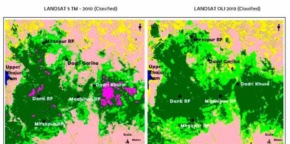
The present study analysed the changes taking place in land use/ land cover and forest cover using multispectral satellite remote sensing data (LANDSAT TM, 2010, and LANDSAT OLI, 2013) around the Patehra, Danti, Mirzapur and Madihan forest ranges in Mirzapur district of Uttar Pradesh, India. Satellite data was visually interpreted to delineate land use and land cover classes. Post classification comparative analysis for both time periods showed agricultural expansion, urbanization and increase in open forests drastically. Further, forest area was extracted from false colour composite (FCC) (using a mask generated from LULC map) and ten forest cover classes were delineated spectrally using digital classification technique. Area statistics were computed and compared for change analysis for the time period 2010-2013). There was a marginal increase in dense mixed forests due to plantation activities, followed by increase in open mixed forest and degraded forest. A remarkable increase in area of grassland and scrubland was also noticed. Rate of change was also quantified. Higher rate of change was observed in case of degraded, fragmented and open scrub, scrubland and grassland. Thus, the forests are getting fragmented at a very fast pace. Results obtained from satellite data analysis can be effectively utilized for monitoring the changes taking place and help in establishing better management practices to conserve these forests.
Authors: Laxmi Goparaju and Debadityo Sinha (Vindhyan Ecology and Natural History Foundation)
Full paper can be downloaded free of cost from here http://apcz.pl/czasopisma/index.php/EQ/article/view/EQ.2015.020/8018